What is an estuary and how is it different from a delta?

When considering large fresh water bodies, it is necessary to find out what the estuary is like. The term refers to the end of the river, the shape of which resembles a funnel. The mouth of such a reservoir consists of one sleeve and becomes wider towards the sea.
How does the estuary appear

An estuary translated from Latin is called "flooded estuary". It has a funnel-shaped and one-arm shape, and can expand towards the sea. In geography, there is an opposite concept - it is a delta, which is a river mouth, divided into channels. The Delta has the Amazon and the Nile. But the mouth of the Volga can be called both a delta and an estuary.
The phenomenon is observed where land with sand is washed out due to sea currents or tides. A depression is formed that is closer to the salt body of water. It is known that estuaries were formed at the Yenisei and Don.
Classification

Scientists distinguish these formations depending on the circulation of water and the geological structure of the soil. It is believed that the oldest estuaries were created by nature many thousands of years ago, when the end of the last ice age was approaching. This is due to lower sea levels. Such species are called coastal plains.
If parts of rivers with indentations are isolated by beaches from the sea, they are called barrier estuaries. These are long and narrow formations parallel to the coastline, about 5 meters deep.
Tectonic estuaries have arisen in places of subsidence of rocks under the influence of volcanoes or landslides. Fresh and seawater is collected in the cavities created by nature if the land is below sea level.
Estuaries that are created by glaciers are called fjords. Large blocks of ice moved toward the ocean and carved deep stripes along the coastlines. After the retreat of the frozen water, the recesses were filled again.
Wedge-shaped estuaries are sections of rivers in which water circulates much more intensively than in others. Moreover, here the tides are considered insignificant. The layer of fresh water gradually decreases in those places where the estuary approaches the sea. The wedge-shaped layer of this site can be seen in places of denser seawater. This type is divided into several subspecies, depending on how the water is mixed. So, geographers distinguish between an intermittent type, which is characterized by complete transitions.
Large estuaries of Russia and the world

The largest estuary is the part of the river called the Gironde. Its length is 72 km. In North Carolina (United States of America), there is a bay called Albemarl. It belongs to large estuaries, separated from the Atlantic Ocean by a chain of External Shoals.
If we consider the territory of Russia, we call the estuary in the form of an estuary. These include formations on the Yenisei and the Ob. The Amur part of the river desalinates the local estuary. The Volga has a similar mouth, although some scholars are inclined to believe that its mouth is still a delta.
Video plotThe mouth is the place where the river meets another body of water. Here you can see a delta or estuary. When part of the water formation dries out as a result of evaporation or human intervention, they speak of a blind mouth. Moreover, not every river has a permanent mouth. Some reservoirs of the plan under consideration may change the course depending on the season.
In general, you need to know that the delta and estuary are two opposing concepts.
Interesting information

The longest rivers of the world
The longest river in the world is the Nile, its length reaches 6653 km. In second place is the Amazon, which flows in Brazil.
The widest rivers of the world
The list of wide world rivers includes the Kama, flowing through the territory of Russia, being the largest tributary of the Volga. It should be noted Amazon (delta width more than 325 km) and the Nile, which are much wider in comparison with other freshwater systems in the world.
The longest river in Russia
Russia has an extensive network of rivers, streams and streams. Many of them do not even have a name. But there are real giants. The longest river in Russia is the Lena with a length of 4,400 km. In second place is the Irtysh, which reaches a length of 4248 km.


-
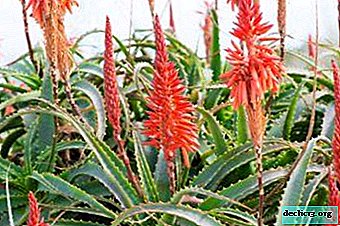
Buds of indoor aloe. How and when does the plant bloom?
Many owners of indoor aloe do not even suspect that it is able to delight in flowers. The plant prefers to bloom in natural conditions, but it is very unpretentious and can take an artificial environment for a natural one. A photo of a blooming aloe in a pot on the windowsill is a convincing argument as to whether the agave blooms at home. ... -

-
-